Apple versus Google: The Amazing Maps Race
Thanks to Google, we have all heard about autonomous or driverless cars. Google’s driverless car is a cute, miniature vehicle that looks like it belongs on the sidewalks of Disney World, driving patrons from the park to their nearby hotel. Google may have popularized the self-driving car, but now, it’s just one of a slew of companies making these amazing vehicles. Big, powerful, and global automotive companies like Ford, Tesla, Mercedes-Benz, Daimler, and Delphi are now making significant progress in assisted-driving technology. However, no matter the self-driving vehicle manufacturer, or how amazing it is promised to be, these vehicles cannot travel an inch without an extremely precise mapping system.
How are Maps created anyway?
According to Google, in order to create a map, a vehicle is first “outfitted with a bank of sensors” and continually makes “repeated passes” on a road, capturing every “square foot of the landscape.” These sensors are scanning the “three-dimensional locations of streetlights, stop signs, crosswalks, lane markings, and every other crucial aspect of a roadway” (Driving in Circles, Slate.com).
Eventually, the data is validated by computers and people to ensure that stationary objects, buildings, and entities are recorded accurately. With four million miles of American roads, there is a lot of mapping work to be done. Currently, the public roads in and around Google’s company headquarters in Mountain View, California have been mapped. Another issue with the mapping is that once created, it’s imperative that they are kept up-to-date.
Although there are several reputable applications in the Maps market (Yahoo! Maps, Bing Maps, and 15 year old MapQuest), the two heavy hitters are considered Apple and Google.
Google Maps was launched 10 years ago in 2005, offering several high-resolution views of satellite images, aerial views, and street views. In addition, Google Maps provides those handy “route planners” under their “Get Directions.” To view its Street View, requires Adobe Flash (we discussed Flash recently in our August Blog. Read about it here.) Google also introduced a mobile map application, adding voice commands and traffic reports. What’s more, Google offers an indoor feature, letting users discover inside buildings like airports, department stores, and malls even letting you switch floors.
Conversely, Apple Maps, launched in 2012 is the newest mapping service and when it launched it bumped Google Maps as the default mapping service from its iPhones and Smartwatches. The background story is that, apparently, Apple wanted to have access to Google’s data for mapping, and Google said…nope. Apple ambitiously launched Maps before it was truly ready with accurate directions. Its directions were considered “glitchy as hell” (Always get lost in the city? Wired.com).
Critics complained about Apple Maps’ improper labeling, errors, and omissions as well as not featuring a Street View. CNN named Apple Maps one of the Top 10 technology failures of 2012.
Hey, is that what I think that is?
However, a lot has changed and improved within three years. Apple has been driving Dodge Caravans around equipped with LiDAR equipment on its roofs to collect “street-level imagery.”
In fact, we spied one of those vehicles in our own parking lot at Media Genesis! Apple is also allegedly taking photos of businesses, storefronts and other points of interest to replace photos currently provided by Yelp and other third parties.
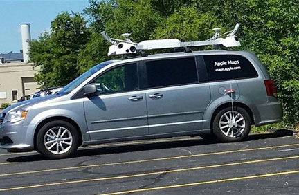
Apple Maps is in the “D.” We were surprised to see this vehicle parked at MediaG recently.
Apple has taken a serious stake in its mapping application by featuring turn-by-turn spoken directions, interactive 3D views and a brand new “flyover feature,” (Google does not have a flyover feature; its Google Earth feature is similar) letting users see 3D videos of select areas that they can zoom in, rotate and pan. In addition, Apple Maps now shows real-time traffic information to calculate your estimated time for arrival.
This past summer, Apple announced that it receives 5 billion requests per week for its mapping service – 3.5 times more frequently than “the next leading maps app” (Why 3.5 times more Apple users choose Apple Maps over Google Maps, Fortune.com). This translates to 78% share for Apple Maps and a 22% share for Google.
Wired Magazine’s Liz Stinson says: “Past failures aside, Apple’s new app looks to be incorporating some human-centered touches that other maps apps have ignored. This shouldn’t be surprising—after all, Apple is known for its attention to design details. The updated app is certainly a nod to the fact that transportation apps are meant to reduce anxiety, not to produce it.”
With the release of iOS 9 expected in the fall 2015, Apple Maps will provide directions for travelers using bus, train, ferry, and subway. Certainly anyone who lives in a city and uses public transportation may appreciate these features. Public transportation navigation data will be available across 10 U.S. cities and 300 cities in China.
The Maps Race is on!
| Maps Feature | Apple | |
| Indoor Maps | X | |
| Directions using city public transportation | X | |
| Flyover | Earth | X |
| Interactive 3D | X | X |
| Satellite / Street View | X | X |
| Turn by turn navigation (voice-guided) | X | X |
Without a doubt, both Apple and Google will be attempting to outdo each other and launch more helpful and user-friendly benefits. Accuracy still trumps anything else when it comes to offering the best maps. With 700 million iPhones sold, it’s understandable that Apple Maps is taking a bite out of Google Maps business.
So where are Maps going?
Inside
Although Maps are generally thought of providing help to travelers outside, more inside views will be included. Google’s Business View lets any business get users a “premium quality, 360 degree virtual tour.”
Offline
Moreover, mapping apps are expected to go offline. Google Maps plans to offer offline support in late 2015. Users will be able to download maps to their devices and then receive the full Google Maps experience, including turn-by-turn voice directions – even when they are offline. This offline support may prove very useful especially in areas around the world where internet connections are inconsistent, slow, or unavailable.
Which map application do you prefer? Why? Drop us a note on social media.
Sources:
http://www.slate.com/articles/technology/technology/2014/10/google_self_driving_car_it_may_never_actually_happen.2.html
http://www.macworld.co.uk/review/reference-education/apple-maps-vs-google-maps-comparison-review-googles-maps-still-better-apple-maps-3464377/
http://www.wired.com/2015/06/always-get-lost-city-apple-maps-will-hold-hand/
http://fortune.com/2015/06/16/apple-google-maps-ios/
http://www.cnet.com/news/google-maps-goes-offline-complete-with-turn-by-turn-directions/

.png)